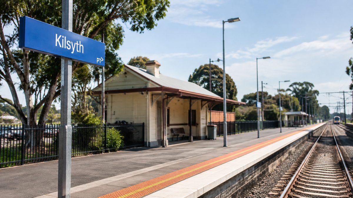
Kilsyth is an eastern suburb of Melbourne, Victoria, about 36 kilometres east of the Melbourne central business district. It sits at the foot of the Dandenong Ranges, between Melbourne's built-up eastern suburbs and the green hills around Montrose. Most of Kilsyth is in Yarra Ranges Shire, while a smaller western section belongs to the City of Maroondah.
That spot can make Kilsyth tricky to place on a map. It is part of metropolitan Melbourne, yet it sits near the point where suburban streets meet bushland, hills and semi-rural areas. Better-known suburbs such as Croydon, Mooroolbark and Bayswater surround it.
Where does Kilsyth sit within Melbourne?
Kilsyth lies in Melbourne's outer east. It is east of Croydon, south of Mooroolbark and west of Montrose. The Dandenong Ranges rise beyond its eastern side, with Mount Dandenong forming one of the best-known high points in the wider area.
The suburb sits well inside metropolitan Melbourne. It isn't a country town, though its eastern edge is greener than suburbs closer to the city. A trip from Kilsyth to central Melbourne usually follows major roads toward Ringwood before heading west. outer eastern Melbourne suburb
Distance looks simple on a map. Travel time doesn't. A person driving toward the city during a weekday peak will feel that Kilsyth is an outer suburb, while someone heading east to Montrose or the hills can reach a less urban setting within minutes.
In my experience, Croydon and the Dandenong Ranges are the easiest reference points. Kilsyth sits beyond Croydon when travelling away from central Melbourne, but before the main climb into the ranges.
Which suburbs share a border with Kilsyth?
Several suburbs surround Kilsyth and form a linked part of Melbourne's east. Mooroolbark, Victoria lies to the north and northwest. Croydon, Victoria is to the west, while Montrose, Victoria sits to the east near the base of the hills.
To the south are Kilsyth South, Victoria and Bayswater North. Despite the shared name, Kilsyth South is a separate suburb. That difference matters when checking an address, school zone, council service or property listing.
Bayswater, Victoria is farther southwest. People often link it with Kilsyth because the areas share industrial, shopping and road links. But Bayswater North sits between parts of Kilsyth and Bayswater, so the suburb names don't mean the same place.
The order is easier to grasp on the road. Travelling west to east, Croydon leads to Kilsyth, then Kilsyth leads to Montrose. From there, roads start climbing into the Dandenong Ranges.
Why do Kilsyth addresses belong to different councils?
Kilsyth crosses a council boundary. Most properties fall within Yarra Ranges Shire, while some addresses on the western side are in the City of Maroondah. This is a normal feature of Local government areas of Victoria, as suburb and council boundaries don't always line up.
A postal address that says Kilsyth doesn't prove which council runs local services for that property. The council handles rubbish collection, local permits, pet registration, rates and some community services. Residents near the western boundary should use an official council map instead of guessing from the suburb name.
This split also explains why two Kilsyth residents may get different council notices. Their homes can share a suburb and postcode but sit under separate local authorities.
Kilsyth South is clearer because it sits within the City of Maroondah. Even so, anyone searching for services should enter the full street address. Leaving out the word South can bring up details for the wrong council area.
Which roads help you find Kilsyth?
Mount Dandenong Road is the clearest road marker. It crosses the area from Croydon toward Montrose and the hills. Drivers coming from central Melbourne often reach Kilsyth after passing through Ringwood and Croydon.
Canterbury Road offers another major route from the southwest. References to Canterbury Road, Melbourne can be unclear because the road runs through many eastern suburbs. Following it outward takes you toward Bayswater North and the southern side of the Kilsyth area, not straight to every Kilsyth address.
Local roads link homes with shops, schools and industrial estates. Some routes look direct on a map but need turns around reserves, large commercial blocks or the council boundary. The full destination matters more than picking a road simply because its name sounds familiar.
A useful way to picture the road network is this:
- From the west: travel through Ringwood or Croydon toward Mount Dandenong Road.
- From the southwest: approach through Bayswater or Bayswater North using Canterbury Road and connecting streets.
- From the east: travel down from Montrose or the lower Dandenong Ranges.
- From the north: approach through Mooroolbark using local north-south roads.
Navigation apps may suggest different routes when traffic is busy. The best way in depends on whether you're heading to northern Kilsyth, the industrial area or somewhere near Kilsyth South.
Is Kilsyth part of the Dandenong Ranges?
Kilsyth sits at the western foot of the Dandenong Ranges, but people usually describe it as an outer eastern Melbourne suburb, not a hill town. Its streets are flatter and more built-up than places higher in the ranges.
The change becomes clear as you travel east. Kilsyth has suburban homes, industrial areas and broad road links. Montrose marks a sharper move into the foothills, and beyond it, the land rises toward Mount Dandenong and other hill communities.
This edge location shapes how people talk about Kilsyth. A visitor from the city may say it's near the Dandenongs. A local may place it in Melbourne's outer east. Both descriptions show the same spot from a different angle.
The weather can show the gap too. Mount Dandenong may be cooler, wetter or foggier while Kilsyth stays clear. Kilsyth is close to the hills, but it doesn't share every trait of the higher settlements.
Why is Kilsyth sometimes confused with Kilsyth South?
Kilsyth and Kilsyth South are two separate suburbs. Their shared name causes mistakes in online searches, delivery bookings and property research. A listing that only says it's in the Kilsyth area could mean either place.
The difference goes beyond a compass point. Kilsyth South is south of Kilsyth and sits within the City of Maroondah. Kilsyth stretches farther north and east, with most of the suburb governed by Yarra Ranges Shire.
I remember helping someone trace a local address with council details that seemed to clash. The street was in Kilsyth South, but the search had been made under Kilsyth. Adding the full suburb name fixed the problem at once.
It's a common map mix-up, not proof that the address has changed. When accuracy matters, use the postcode and street name along with the suburb name. This helps confirm council records, delivery areas and travel directions.
How far is Kilsyth from central Melbourne?
Kilsyth is about 36 kilometres east of the Melbourne central business district, based on the suburb's general location. A road trip is often longer because drivers must follow the available main roads.
Driving time can change sharply. Peak traffic around Croydon, Ringwood and the major east-west roads may add time, while the trip is more direct outside busy periods. Public transport usually needs a bus connection because Kilsyth doesn't have its own railway station.
Croydon and Mooroolbark are the nearest useful rail hubs for many addresses. The best station depends on the starting street and bus route. Someone in western Kilsyth may naturally go through Croydon, while Mooroolbark may suit a person in northern Kilsyth better.
A distance figure misses this detail. Kilsyth is close to several rail lines on the map, but the trip starts with a local road or bus ride. Visitors should plan that final part before leaving the city.
What does Kilsyth's postcode tell you?
Kilsyth uses postcode 3137. Kilsyth South also uses 3137, so a postcode by itself can't tell the two suburbs apart.
Postcodes help sort mail. They don't set council boundaries and may cover more than one named place. A 3137 address may still need the full suburb name before a map, courier or government form finds the right location.
Postcode search results can also mix businesses and services from both suburbs. Check the street address before deciding that a result is in Kilsyth itself.
What is the clearest way to place Kilsyth on a mental map?
Start in central Melbourne and move east through the established suburbs toward Ringwood, then keep going past Croydon. Kilsyth sits after Croydon and before Montrose. East of the suburb, the land rises more clearly toward Mount Dandenong.
From another direction, start at Bayswater and travel northeast through Bayswater North. This takes you toward Kilsyth South and the lower part of Kilsyth. From Mooroolbark, head south or southeast to reach the northern side.
These routes show Kilsyth's Kilsyth's main place on the map. It links Melbourne's eastern suburban belt with the foothills. Nearby centres are easy to reach, even though the suburb has no railway station or single landmark that marks its centre.
Your exact street also changes how the suburb feels. A home near Croydon may seem closely tied to Maroondah services and transport, while an address toward Montrose can feel much nearer to the hills. Both still belong to Kilsyth when they sit inside the official suburb boundary.
How can you confirm that an address is really in Kilsyth?
Enter the full street address into an official Victorian map or the right council's property search. Check whether the result shows Kilsyth or Kilsyth South, then confirm whether it falls within Yarra Ranges Shire or the City of Maroondah.
Follow this order:
- Enter the street number and street name.
- Confirm the suburb label and postcode 3137.
- Check the municipal boundary if you need council services.
- Review the route from Croydon, Mooroolbark or Bayswater North before travelling.
Actionable takeaway: place Kilsyth east of Croydon and west of Montrose, then check the full address because the suburb crosses a council boundary and shares its postcode with Kilsyth South.